|
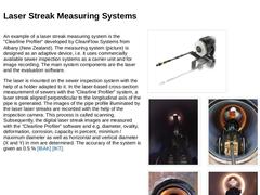
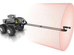
An example of a laser streak measuring system is the "Clearline Profiler" developed by CleanFlow Systems from Albany (New Zealand). The measuring system (picture) is designed as an adaptive device, i.e. it uses commercially available sewer inspection systems as a carrier unit and for image recording. The main system components are the laser and the evaluation software. The laser is mounted on the sewer inspection system with the help of a holder adapted … |
|
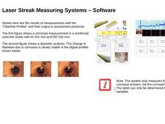
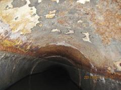
Shown here are the results of measurements with the "Clearline Profiler" and their output in assessment protocols. The first figure shows a corrosion measurement in a reinforced concrete sewer with ID 451 mm and OD 533 mm. The second figure shows a diameter analysis. The change in diameter due to corrosion is clearly visible in the digital profiles shown below. (Image: Laser Streak Measuring System in the sewer with indication of the deformation) (Image: … |
|
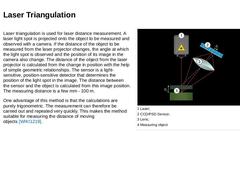
Laser triangulation is used for laser distance measurement. A laser light spot is projected onto the object to be measured and observed with a camera. If the distance of the object to be measured from the laser projector changes, the angle at which the light spot is observed and the position of its image in the camera also change. The distance of the object from the laser projector is calculated from the change in position with the help of simple … |
|
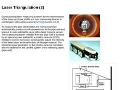
Corresponding laser measuring systems for the determination of the cross-sectional profile are laser measuring devices in combination with a video camera [NN95g] (section 4.1.2). To measure the pipe deformation, the measuring head automatically positions itself perpendicular to the pipe wall and scans it in user-selectable steps with a laser distance sensor. The scattered radiation reflected from the pipe wall is bundled by an optical system and fed … |
|
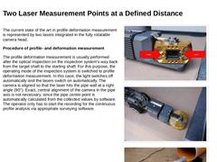
The current state of the art in profile deformation measurement is represented by two lasers integrated in the fully rotatable camera head. Procedure of profile- and deformation measurement The profile deformation measurement is usually performed after the optical inspection on the inspection system's way back from the target shaft to the starting shaft. For this purpose, the operating mode of the inspection system is switched to profile deformation … |
|
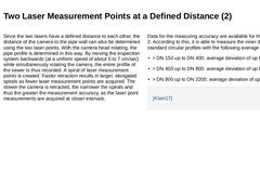
Since the two lasers have a defined distance to each other, the distance of the camera to the pipe wall can also be determined using the two laser points. With the camera head rotating, the pipe profile is determined in this way. By moving the inspection system backwards (at a uniform speed of about 5 to 7 cm/sec) while simultaneously rotating the camera, the entire profile of the sewer is thus recorded. A spiral of laser measurement points is created. … |
|
The profile deformation measurement is not only used for damage assessment but also provides essential information for the planning of renovation measures, e.g. in the form of "CIPP - cured-in-place pipes" for the fabrication of CIPP liners. By adapting the ordering dimensions of the liners to the real maximum and minimum profile dimensions over the entire length of the respective pipe, liners can be manufactured whose elongation behavior … |
|
This module gives an overview of methods of inspection from the inside for quantitative condition assessment. It is to be understood as a supplement to the module "Optical inspection from the inside for qualitative condition recording" and thus belongs in terms of content to the topic block "INVESTIGATION", the first of the four basic activities within the framework of the integral urban drainage management according to EN 752. The procedures presented here provide an essential basis for the assessment of the performance of the drain and sewer system or for developing the rehabilitation plan. After completing this module, you will have a sound knowledge of: - Areas of application and
- Methods of quantitative condition assessment.
|

|
Aug 29, 2013
Article
Kikuhito Kawasue
By Kikuhito Kawasue and Takayuki Komatsu
|
|
Jul 30, 2014
Article
Pure Technologies Ltd.
A Review and Analysis of More than 400 Miles of Force Main Inspection and Condition Assessment Data.
|
|
Aug 16, 2012
News
Jake Wells
Pipeline Analytics, the company delivering WinCan pipe inspection and asset management software to North and South America markets, has achieved Silver Status in the Esri Partner Network. This accreditation recognizes WinCan software for having robustly integrated Esri’s ArcGIS geospatial technology platform, and the Pipeline Analytics team for having become fully conversant in this platform.
|
|
Nov 22, 2012
News
Steve Napoleon
Insight Vision has just concluded a six month project to upgrades and improvements on the Vutek and D2 Camera Inspection Systems. This project has resulted in the implementation of over 30 different changes to the system that will result in a more robust and durable system.
|
|
Jan 04, 2013
News
Terry Peristerakis
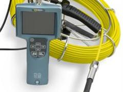
With a Convenient Portable Design and High Resolution Video, the iSnake Push Camera from Fiberscope.Net takes Portable Field Inspections to the Next Level.
|
|
Jan 04, 2013
News
Jake Wells
Attaching in seconds to the ROVVER X inspection crawler, the new RedLine™ laser accessory is all you need to geometrically profile the inside of buried pipelines. Captured profile data is readily analyzed to verify proper pipe installation, plan relining projects, determine remaining pipe life, monitor erosion/corrosion, quantify defects, and analyze partial collapses.
|
|
Mar 05, 2013
News
Fusion Group Ltd.
RedBox has been given the official nod for its role in improving PE pipe jointing: compulsory specification by Severn Trent Water to their contractors.
|
|
May 27, 2013
News
Hradil Spezialkabel GmbH
Frequent repairs due to cable breakage are a thing of the past with the new HRADIL HB44® pushrod cable. This makes it possible to achieve annual cost savings of up to 1,000 EUR. Field trials carried out by Stuttgart University have confirmed the breakthrough. The HRADIL HB44® pushrod cable can be used with all standard CCTV pushrod systems.
|

|
Jun 10, 2013
News
Robert Loadsman
MidCoast Water’s sewer line investigation work is heading to Gloucester. The sewer line investigation program aims to correctly map the sewer network, identify potential problems so they can be resolved and undertake periodic cleaning of the mains.
|
|
(Image: Scientific disciplines of geotechnology with reference to [Floss00] [Image: S&P GmbH]) Geotechnology is a branch of civil engineering concerned with soil or rock as a subsoil and structural material and with the means for investigating its condition and structural utility for construction of stable and functional structures [Schmi96]. The following scientific disciplines, among others, belong to the Geotechnology subject area (Bild 4.1) [Schmi96] : |
|
Sources of information that can be used for this purpose are: - For geological or engineering geological conditions: Geological departments of local governments, universities, building departments or authorities and clients;
- For hydrological conditions: community and regional government departments for water conservation, water supply companies;
- For civil engineering history: underground construction, road works, meteorological, environmental and mountain …
|
|
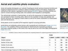
(Image: Example of an aerial photograph (original scale approximately 1:5000) [FI-Spang] taken by [FI-Aerow]) Aerial and satellite photographs are methods of geological remote sensing (meaning recording and mapping of appearances from a distance without immediate contact to the object). Geophysical methods are also utilized in geological remote sensing [Reute92]. Various recording methods are used for remote sensing including radar, heat radiation (… |
|
Irreplaceable for a first estimation of the feasibility and for determination of a subsequent direct investigation program is the surface access and inspection of the planned project alignment and its nearby surroundings. By means of engineering geological overview-mapping of existing explorations, by means of observations of the morphological and hydro-geological conditions and also with a view to hillside movements and observing the vegetation, … |
|
Preliminary exploration measures are carried out at the beginning of planning. The acquisition and analysis of already existing documents and archive material as well as a site visit permit a first orientation of the existing subsoil conditions and assist in the selection of subsequent detailed measures in the main exploration phase. The following possibilities are available for preliminary exploration [Kraut98] : - Studying and evaluation of existing …
|
|
Natural exploration is the opening up of the underground (e.g. by the effect of geodynamic processes) in which the rock or soil material or the geological strata sequence can be investigated. In mountainous regions for instance, natural explorations are hillsides at which rock material strata are visible and in flat lands, erosion channels can be inspected. In the same sense, exposed deposit (e.g. of sand, clay or gravel) must be assessed in the course … |

|
In large projects, e.g. when jacking pipes of large diameter in which the soil is excavated at greater depths, deep explorations in the form of exploration galleries and shafts can be useful. These hand mining explorations permit extensive engineering geological acquisitions and sampling. |
|
A trial pit (pit or trench to DIN 4124 [DIN4124:2002]) is an artificially created excavation for inspecting the subsoil, for sampling and for carrying out field tests [DIN4021]. It can be man accessible or non-man-accessible. Trial pits are suitable mainly for explorations above the groundwater level and for low investigation depths [DIN4021]. As a rule, trial pits are unsuitable for inner urban regions due to the artificial surfacing and the intensive … |