Satellite Data Shows Sustained Severe Drought in Europe
Feb 10, 2023
Europe lacks groundwater – a lot of groundwater. The continent has already been suffering from a severe drought since 2018. This is confirmed by satellite data analysed at the Institute of Geodesy at TU Graz.
The beginning of this tense situation is documented in a publication by Eva Boergens in Geophysical Research Letters (https://agupubs.onlinelibrary.wiley.com/doi/10.1029/2020GL087285) from the year 2020. In it, she noted that there was a striking water shortage in Central Europe during the summer months of 2018 and 2019. Since then, there has been no significant rise in groundwater levels; the levels have remained constantly low. This is shown by data analyses by Torsten Mayer-Gürr and Andreas Kvas from the Institute of Geodesy at Graz University of Technology (TU Graz). As part of the EU's Global Gravity-based Groundwater Product (G3P) project, they used satellite gravimetry to observe the world's groundwater resources and documented their changes in recent years.
Far-reaching consequences
The effects of this prolonged drought were evident in Europe in the summer of 2022. Dry riverbeds, stagnant waters that slowly disappeared and with them numerous impacts on nature and people. Not only did numerous aquatic species lose their habitat and dry soils cause many problems for agriculture, but the energy shortage in Europe also worsened as a result. Nuclear power plants in France lacked the cooling water to generate enough electricity and hydroelectric power plants could not fulfil their function without sufficient water either.
Groundwater measurement from space
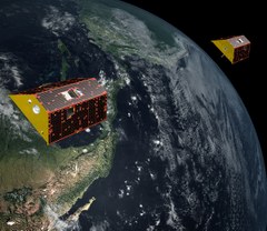
How can the geodesists at TU Graz use data from space to make accurate statements about groundwater reservoirs? At the heart of the G3P project are twin satellites named Tom and Jerry, which orbit the Earth in a polar orbit at an altitude of just under 490 kilometres. The distance between the satellites of around 200 kilometres is important. The one behind must not catch up with the one in front, which is why they have been given the name Tom and Jerry in reference to the cartoon characters.
The distance between the satellites is being constantly and precisely measured. If they fly over a mountain, the satellite in front is initially faster than the one behind because of the increased mass under it. Once it has passed the mountain, it slows down slightly again, but the rear satellite accelerates as soon as it reaches the mountain. Once both are over the mountain, their relative speed is established once more. These changes in distance over large masses are the main measurement variables for determining the Earth's gravitational field and are ascertained with micrometre precision. As a comparison, a hair is about 50 micrometres thick.
 Monthly gravity map of the Earth
All of this happens at a flight speed of around 30,000 km/h. The two satellites thus manage 15 Earth orbits a day, which means that they achieve complete coverage of the Earth's surface after one month. This in turn means that TU Graz can provide a gravity map of the Earth every month. “The processing and the computational effort here are quite large. We have a distance measurement every five seconds and thus about half a million measurements per month. From this we then determine gravity field maps,” says Torsten Mayer-Gürr.
Mass minus mass equals mass
However, the gravity map does not yet determine the amount of groundwater. This is because the satellites show all mass changes and make no distinction between sea, lakes or groundwater. This requires cooperation with all other partners in the EU G3P project. Torsten Mayer-Gürr and his team provide the total mass, from which the mass changes in the rivers and lakes are then subtracted, the soil moisture, snow and ice are also subtracted and finally only the groundwater remains.
Each of these other masses has its own experts who contribute their data here. These are located in Austria (Graz University of Technology, Vienna University of Technology, Earth Observation Data Center EODC), Germany (GeoForschungsZentrum GFZ in Potsdam), Switzerland (University of Bern, University of Zurich), France (Collection Localisation Satellites CLS, Laboratoire d'Etudes en Géophysique et Océanographie Spatiales LEGOS, Magellium), Spain (FutureWater), Finland (Finnish Meteorological Institute) and the Netherlands (International Groundwater Resources Assessment Centre IGRAC).
Europe has a water problem
The result of this cooperation shows that the water situation in Europe has now become very precarious. Torsten Mayer-Gürr had not expected this on such a big scale. “A few years ago, I would never have imagined that water would be a problem here in Europe, especially in Germany or Austria. We are actually getting problems with the water supply here – we have to think about this,” he explains. From his point of view, it is first of all necessary to be able to document the continuing drought using data and to have continuous satellite missions on this in space.
The European Space Agency ESA and its US counterpart NASA will continue this research with the MAGIC (Mass-change And Geoscience International Constellation) project. TU Graz will again be on board for the data evaluation.
More News and Articles
Aug 07, 2025
News
Kanalgipfel 2025: Netzweite operative Bedarfsplanung mittels individuellem Sanierungskosten- und Entscheidungsmodell
Die Entwässerungssysteme unserer Städte sind ein wesentlicher Bestandteil des kommunalen Anlagevermögens. Die große Zukunftsaufgabe, …
May 26, 2025
News
Kanalgipfel 2025: Smart Processing – mit KI-Technologien von der Kanalinspektion bis zur Sanierungsstrategie
Die Entwässerungssysteme unserer Städte sind ein wesentlicher Bestandteil des kommunalen Anlagevermögens. Die große Zukunftsaufgabe, …
May 12, 2025
News
Kanalgipfel 2025: Stand der Kanalsanierung in Deutschland – Eine kritische Betrachtung
Die Entwässerungssysteme unserer Städte sind ein wesentlicher Bestandteil des kommunalen Anlagevermögens. Die große Zukunftsaufgabe, vor der viele Kommunen …
Aug 28, 2024
News
ITpipes Secures $20M to Transform Water Infrastructure Management
ITpipes announced it has secured $20 million in equity financing from Trilogy Search Partners and Miramar Equity Partners.
Known for its trusted and user-friendly platform, ITpipes …
Aug 26, 2024
News
Professor Dr.-Ing. Dietrich Stein
With deep sadness we announce the loss of our founder and partner Prof Dr Dietrich Stein at the age of 85.
Engineers around the globe are thankful for his dedication to the inventions in the fields of sewers, …
Aug 26, 2024
News
PPI Releases New Installation Guide for PE4710 Pipe
PPI’s MAB-11-2024 Covers HDPE Water Pipelines Up to 60-in. Diameter and 10,000-ft Long Pulls
Developed by the Municipal Advisory Board (MAB) – and published with the help of the members of the …
Aug 23, 2024
News
Faster wide-scale leak detection now within reach
Mass deployment of connected leak loggers is being made possible by the latest technology, writes Tony Gwynne, global leakage solutions director, Ovarro
Water companies in England and Wales are …
Aug 21, 2024
News
Kraken awakens customer service potential in water
The innovative customer service platform Kraken has made a successful transfer from energy to water. Ahead of their presentation at UKWIR’s annual conference, Portsmouth Water chief executive …
Aug 19, 2024
News
Predicting the toxicity of chemicals with AI
Researchers at Eawag and the Swiss Data Science Center have trained AI algorithms with a comprehensive ecotoxicological dataset. Now their machine learning models can predict how toxic chemicals are …
Aug 16, 2024
News
Goodbye water loss: Trenchless pipe renewal in Brazil
Pipe renewal in Brazil
How do you stop water loss through leaks in old pipe systems without major environmental impacts and restrictions? The answer: with trenchless technology, or more precisely …
Aug 14, 2024
Article
Impact of high-temperature heat storage on groundwater
In a recently launched project, the aquatic research institute Eawag is investigating how the use of borehole thermal energy storage (BTES) affects the surrounding soil, the groundwater …
Aug 12, 2024
News
Watercare completes East Coast Bays sewer link
Watercare has successfully finished the final connection on the East Coast Bays link sewer at Windsor Park in New Zealand.
Much of the East Coast Bays sewer link was installed using horizontal directional …
Contact
Technische Universität Graz
Univ.-Prof. Dr.-Ing. Torsten Mayer-Gürr
Institute of Geodesy
Rechbauerstraße 12
8010 Graz
Austria
Phone:
+43 316 873 6359
