|
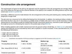
The requirements of space for the drill rig, the approach and the equipment of the site arrangement are strongly influenced by the size of the drilling rig, the type and the external diameter of the pipe(s) to be installed, the drilling distance and the selected pulling-in variant (see (Method of operation and sequence)) [HDD-55]. Generally, a difference must be made between the site arrangement at the entry point (starting pit) or starting shaft … |
|
|
|
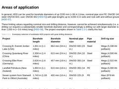
In general, HDD can be used for borehole diameters of up 2200 mm (≈ 86 in.) (max. nominal pipe size PE: DN/OD 1400 (1500), steel: DN/OD 820, cast: DN/OD 842 [HDD-5]) with pipe lengths up to 3,000 m in soils and rock with and without groundwater [HDD-57]. These limiting values regarding nominal size and drilling distance, however, cannot be achieved simultaneously (i.e. a very long drilling run requires a substantially smaller borehole diameter and … |
|
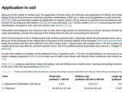
Because of the variety in drilling tools, the application of these tools, the methods and parameters of drilling, the characteristics of drilling fluid and fluid pressures and their possible combinations, HDD has a wide area of application in soils and rock. According to [HDD-61], they are basically suitable for application in organic (Class LO) as well as in cohesive and noncohesive soils of Classes LB and LN according to DIN 18319 [HDD-62] or in … |
|
(Image: Difficulty levels when using HDD in rock – case examples for different subsoil conditions)Today in practice, drilling in rock of classes FZ 1/FD 1 to FZ 4/FD 4 (see DIN 18319 [HDD-62]) is possible with drill rigs with a pullback of ≥ 100 kN and by using roller cutting heads driven inside the borehole for pilot boring or hole openers (see (Drilling tools)) for reaming(s). Concerning the technical aspect of drilling, there are no limitations … |

|
In general, HDD can be used for borehole diameters of up 2200 mm (≈ 86 in.) (max. nominal pipe size PE: DN/OD 1400 (1500), steel: DN/OD 820, cast: DN/OD 842 [HDD-5]) with pipe lengths up to 3,000 m in soils and rock with and without groundwater [HDD-57]. These limiting values regarding nominal size and drilling distance, however, cannot be achieved simultaneously (i.e. a very long drilling run requires a substantially smaller borehole diameter and … |
|
HDD used in trenchless installation is counted among the near-surface directional drilling methods. While drilling, its spatial path is controlled and, if necessary, directionally oriented or influenced by means of technical or technological measures for the purpose of corresponding to the planned drilling profile [HDD-67] [HDD-68]. This influencing not only includes the maintenance of the prescribed drilling profile, but also the correction of natural … |

|
The following components are used for both variants of the measuring system: - transmitter (sonde, probe, beacon),
- receiver (with display and data logger, where necessary),
- data display device (monitor).
|

|
(Image: Structure of a transmitter using the example of the PDF (Precision Dual Frequency DataSonde) by the company Radiodetection)Electromagnetic Walk-Over methods, also called active Walk-Over methods, are used in about 90% to 95 % of all cases of HDD [HDD-69] [HDD-72]. They are used with Mini to Mega drill rigs. Depending on the power supply of the transmitter, it is differentiated between the following variants: -
electromagnetical Walk-Over methods …
|

|
(Image: View and structure of the pneumatically driven pilot boring head (displacement head) with integrated permanent magnet as a transmitter)Magnetic or passive Walk-Over methods work with a permanent magnet as a transmitter (passive transmitter) inside the drill head (Figure 83) and are scarcely employed in practice. The receiver locates the magnetic field via four magnetometers inside a sensor plate (Figure 84 a). The magnetometers send this … |

|
The following components are used for both variants of the measuring system: - transmitter (sonde, probe, beacon),
- receiver (with display and data logger, where necessary),
- data display device (monitor).
|

|
The Wire-Line method is a locating technique with cable (direct) based on the natural terrestrial magnetic field or, if required, based on an artificially generated magnetic field. It originates from deep drilling technology and is mainly used with large drill rigs and correspondingly long and deep drillings. The most important system components are: -
non-magnetic drill rod with sensors and transmitter,
-
data transmitting cable,
-
steering desk.
Sensors … |
|
The following locating techniques, for example, belong to alternative locating techniques that are only employed in major drilling technology: -
gyroscope,
-
parallel bore measuring method,
-
positioning of a magnetic field sensor in the environment of the drill path.
DWA-A 125 [HDD-10] recommends to employ a gyroscope or gyro compass or the parallel bore measuring method in hardly accessible or non-accessible areas with strong magnetic interferences. |
|
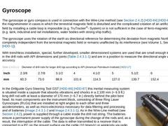
The gyroscope or gyro compass is used in connection with the Wire-Line method (see (Wire-Line method)) [HDD-84] [HDD-85]. It replaces the magnetometer in cases in which the terrestrial magnetic field is disturbed and the complicated creation of an artificial magnetic field by installing a cable loop is impossible (e.g. TruTracker®- System) or is not sufficient in the case of ferro-magnetic influence (e.g. tank, industrial and rail installations, … |
|
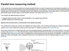
In the parallel bore measuring method an already created drill bore is used for steering and controlling the parallel, subsequent pilot bore(s) by employing corresponding measuring technology (soft- and hardware). This measuring and locating techniques is used if drillings have to be carried out in a parallel way and with relatively small clearance on the sides and /or in the limits of the minimally permissible elastic bending radius or permissible … |
|
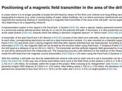
In cases where it is no longer possible to locate the drill head by means of the Wire-Line method over long drilling sections due to topographical reasons (e.g. when crossing bodies of water, below buildings, etc.) or where enormous interferences are to be expected the measuring method of “positioning of a magnetic field transmitter in the area of the drill path“ can be applied from the very beginning or as a supporting measure. A representative system … |

|
The following locating techniques, for example, belong to alternative locating techniques that are only employed in major drilling technology: -
gyroscope,
-
parallel bore measuring method,
-
positioning of a magnetic field sensor in the environment of the drill path.
DWA-A 125 [HDD-10] recommends to employ a gyroscope or gyro compass or the parallel bore measuring method in hardly accessible or non-accessible areas with strong magnetic interferences. |

|
HDD used in trenchless installation is counted among the near-surface directional drilling methods. While drilling, its spatial path is controlled and, if necessary, directionally oriented or influenced by means of technical or technological measures for the purpose of corresponding to the planned drilling profile [HDD-67] [HDD-68]. This influencing not only includes the maintenance of the prescribed drilling profile, but also the correction of natural … |

|
In carrying out drillings, difficulties in part are inherent to this type of work repeatedly occur and thus lead to enormous financial losses on the client’s as well as on the contractor’s side. These failed drillings also are frequently caused by insufficient construction preparations as well as insufficient geotechnical investigations or explorations by the client and the contractor. Such investigations are a critical part of the use of this method [… |

|
(Image: Influence of the subsoil on HDD)For using HDD methods, accurate and comprehensive information on the subsoil, based on qualified and targeted subsoil investigations carried out by the client, is a necessity in order to be able to ensure its feasibility and to reduce the subsoil risk to a minimum [HDD-17]. The building owner as the client is basically responsible for the subsoil and its associated characteristics. Also, in line construction, … |
|
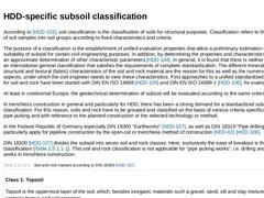
According to [HDD-103], soil classification is the classification of soils for structural purposes. Classification refers to the categorizing of soil samples into soil groups according to fixed characteristics and criteria. The purpose of a classification is the establishment of unified evaluation properties that allow a preliminary estimation of the suitability of subsoil for certain civil engineering purposes. In addition, by determining the properties … |
|
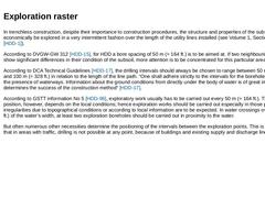
In trenchless construction, despite their importance to construction procedures, the structure and properties of the subsoil can only economically be explored in a very intermittent fashion over the length of the utility lines installed (see Volume 1, Section 4.5 [HDD-1]). According to DVGW-GW 312 [HDD-15], for HDD a bore spacing of 50 m (≈ 164 ft.) is to be aimed at. If two neighbouring drill profiles show significant differences in their condition … |
|
The exploration depth must include all layers that are to be drilled through in the HDD project. Furthermore, in drillings through subsoil with groundwater, additionally the exploration depth must be determined according to the hydrogeological conditions. For HDD, the DCA [HDD-17] recommends to sink exploratory boreholes 2 m to 5 m (≈ 6.5 ft. to 16.4 ft.) below the planned line axis. This provides an additional explored area in case a change of borehole … |

|
(Image: Influence of the subsoil on HDD)For using HDD methods, accurate and comprehensive information on the subsoil, based on qualified and targeted subsoil investigations carried out by the client, is a necessity in order to be able to ensure its feasibility and to reduce the subsoil risk to a minimum [HDD-17]. The building owner as the client is basically responsible for the subsoil and its associated characteristics. Also, in line construction, … |
|
HDD is to be used in such way that structures owned by third parties are not endangered. The corresponding requirements by DVGW-GW 315 [HDD-114], DVGWGW 316 [HDD-78] and DVGW Data Sheet W 380 [HDD-115] must be taken into account and adhered to [HDD-15]. According to DIN 18319 [HDD-62] [HDD-108], in the interest of an interruption-free construction process and for the protection of possibly endangered persons, it is necessary to also gain knowledge … |